
Citizen science – and I helped!
- By Sara Mitchell
- July 16, 2010
- Comments Off on Citizen science – and I helped!
My house started rumbling at 5:04 this morning. I was instantly awake. Was it thunder? A low-flying jet? It lasted a little too long for either of those scenarios – and it was really a sensation, not a noise. I was pretty sure we’d just experienced an earthquake here in the Washington, DC, suburbs.
Yes, a quake! They’re unusual on this coast, and it’s easy to forget that there are fault lines everywhere – both active and inactive. The last earthquake I recall was in 2003, and the trailer I was working in here at Goddard shuddered exactly like it did whenever the garbage truck rolled by. I didn’t think anything of it until someone mentioned that there had been an earthquake in central Virginia.
This morning, I knew exactly what to do. In our link round-up on June 28th, we’d shared a U.S. Geological Survey citizen science project called Did You Feel It? – and I’d definitely felt it! So I ran to the computer and told the USGS what I’d felt. So did hundreds of other DC area folks who were up at 5AM and wondering what was going on. Our data created a real-time map:

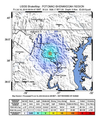
Within 30 minutes, a seismologist at the USGS had reviewed the data coming from their instruments, and they released an official instrument intensity map of the earthquake. Look how similar it is to the one generated from citizen science data!
It felt really good to be part of something like this. I helped the USGS collect data – not with the sensitivity and nuance that their instruments can get, but of different value to them. Their FAQ explains that the project’s data is used for rapid assessment and confirmation of events, and actually provides data that they can’t collect (whether it’s because of earthquake location or intensity). It was also powerful to have all of the real-time data at my fingertips from the USGS and the Maryland Geological Survey. Their online helicorder shows a huge blip for this morning’s event.
I know that my friends and colleagues in California are probably rolling their eyes about about our baby earthquake this morning. It’s business as usual for them to have some little rumbles – and a significant risk of some big ones, too. Back in 1989, my dad stepped onto a jetway in Oakland Airport just in time for the Loma Prieta earthquake (magnitude 6.9). It was scary – these were the days before cellphones and real-time data websites, and we were left for hours wondering if he was alright. Tools such as “Did You Feel It?” make it easier for first responders and the rest of the world to stay informed about these events.
Intensity maps courtesy of the U.S. Geological Survey.