
Multiwavelength Milky Way: Using the Multiwavelength Maps
![]()
I. Map coordinates
II. Locating an object on the Multiwavelength maps
I. Reading the Multiwavelength maps is very much like reading a map of the Earth.
Just like a map of the Earth has latitude and longitude, so does the Multiwavelength
image maps. You'll notice that here, we use "Galactic Longitude" and "Galactic
Latitude."
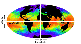
MODIS Global sea surface temperature map.
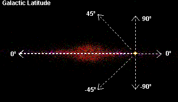
Latitude on an Earth map, is measured north and south of the Earth's equator (latitude = 0 degrees). In the "Galactic" coordinate system, galactic latitude is measured above and below the equator of the galaxy - the galactic plane.
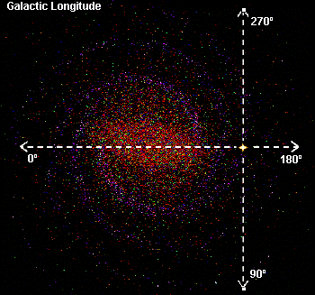
Galactic longitude is measured from the direction to the galaxy's center (longitude = 0 degrees). This is equivalent to the Prime Meridian on Earth.
The edge-on and face-on views of the Milky Way galaxy , shown in the galactic latitude and longitude images to the left, are VRML models of our galaxy. The star, sitting at the intersection of the dashed arrows, respresents our location within the galaxy.
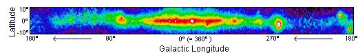
The images seen on the poster, in the video, and online are only a part of the sky that we can see. These images are only of that part of the Milky Way galaxy that is within 10 degrees of the galactic plane. If an object you were searching for had a latitude of +45 degrees, it wouldn't be seen on the multiwavelength maps. However, it could be seen on an all-sky slide.
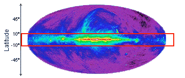
On the images, 0 degrees longitude is at the map's center. Looking to the left of center, takes you from 0 degrees to 180 degrees. The rightmost edge of the map picks up at 180 degrees and goes up to 360 degrees (which puts you back at 0 degrees) as you move toward the center of the map.
Back to top
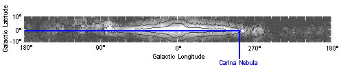
II. Located at the bottom of the Multiwavelength Milky Way poster and the online images, is a finder chart which names some objects which can be seen on the maps. Galactic latitude and longitude coordinates can be read off of the chart.
For example, The Carina Nebula can be found at galactic longitude = 288 degrees (approximately), and galactic latitude = -0.8 degrees (approximately).
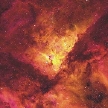 Credit: K. Weis & W. J. Duschl (ITA, U. Heidelberg) |
Within the Carina Nebula (left) lies one of the brightest stars in the sky - Eta Carinae (right). In the optical image to the right, you see huge clouds of gas and dust being thrown off of this star. |
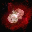 Credit: NASA/HST/J. Morse/K. Davidson |
Related Online Resources:
Conversion tool - Convert Equatorial to Galactic Coordinates
Galactic Navigation - A tutorial from the Chandra X-ray Observatory
Understanding Celestial Coordinates - From Sky and Telescope magazine